
Meteorologists confirm that Australia will cop third La Niña right on time to ruin summer
Someone call the Australian Federal Police because this Down Under nation has fallen victim to a crime.
A weather-related crime against humanity that is.
Yes, the boffins at the Bureau of Meteorology has declared a third La Niña is now underway.
That means Aussies should batten down the hatches and gear up for another wet and wild summer.
Advert
The good news is you can cancel that beach bod prep for two reasons. 1 - everybody is a beach body. 2 - It's going to be pissing it down all summer, so unless you plan to hit the sand and surf in the rain, then what's the point?
Anyway, if you can still read this through your tears, BOM confirmed the weather event is now impacting the tropical Pacific, with a third-in-a-row spring and summer season coming that will boast above-average rainfall along Australia's east coast.
So if you're going to any summer festivals, have your brollies and gumboots at the ready and be prepared for a Splendour-in-the-Grass-2022-type camping catastrophe.
Meteorologists have finally confirmed the three-in-a-row is due to the infrequency of three miserable spring-summer periods in a row.
Two La Niñas in a row is pretty common, but there have only been two or three of these awful rainy triple-deckers since modern records began in 1900.
So yeah, that's great.
So what does that mean for your summer plans?
Well, the return of the icy-cold temptress will mean more rainfall and cooler daytime temperatures south of the tropics.
In the tropics, you'll have warmer overnight temperatures as if you didn't need a break from living in an actual oven.
Aussies might also see shifts in temperature extremes which can mean increased tropical cyclone numbers and the earlier onset of monsoons.
More flood risks are also on the cards like Australia hasn't had enough of that type of disaster just yet.
So it's time to literally batten down the hatches, people.
BoM head of long-range forecasts Dr Andrew Watkins told 7News that the three-month climate outlook shows a high chance of above-average rainfall for most of Australia's east coast for both the mainland and eastern Tasmania.
"La Niña is not the only driver influencing this wet outlook,” Dr Watkins said. “To our west, a significant negative Indian Ocean Dipole (IOD) event is underway. We expect the IOD influence will reduce in late spring or early summer."
He also revealed that as well as La Niña, SAM will also swing by for a visit.
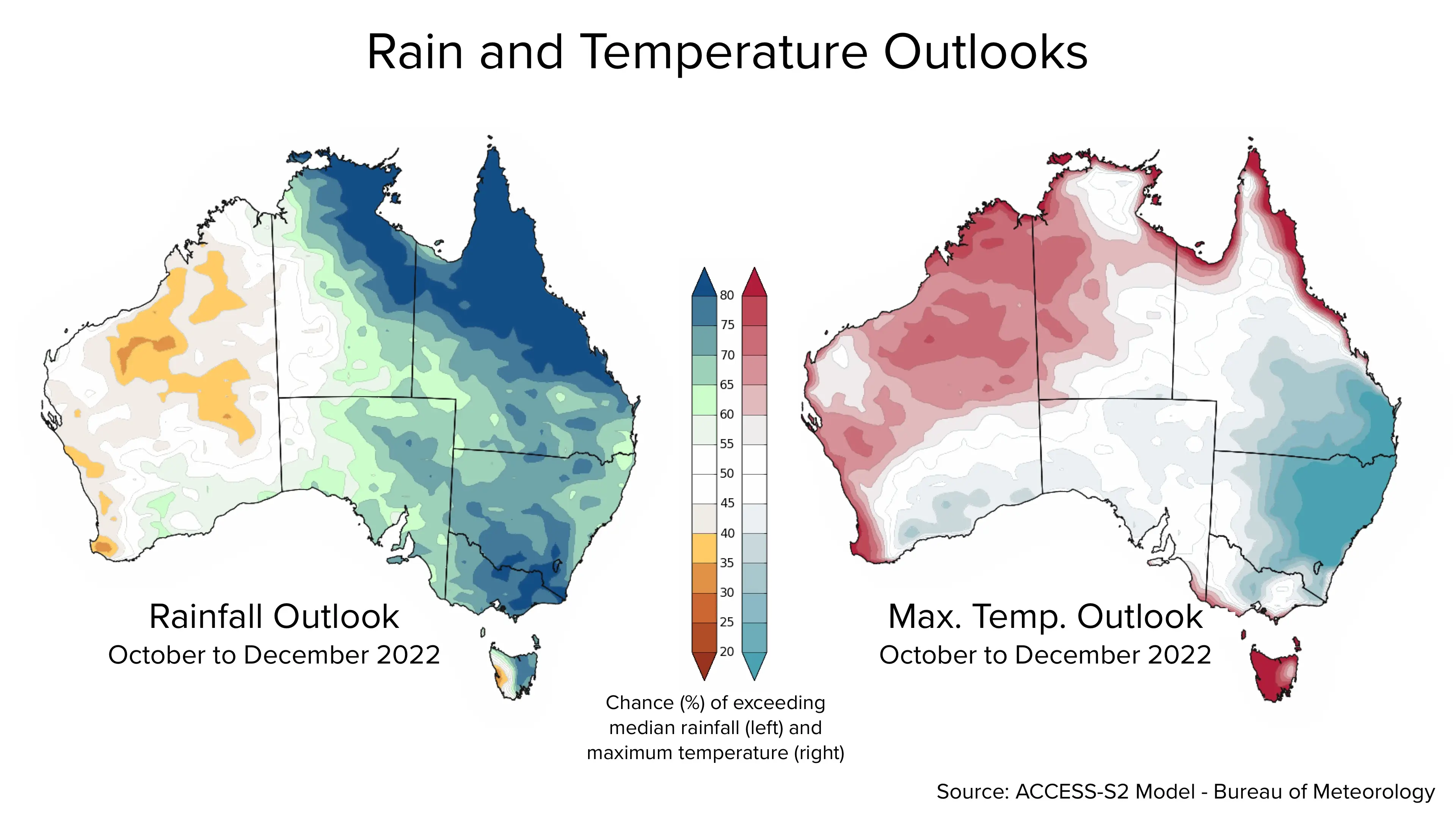
“The Southern Annular Mode (SAM) is also in a positive phase, and likely to remain positive into summer," Dr Watkins said as per 7News.
“Positive SAM during summer pushes weather systems south, which increases the chance of rain in New South Wales, eastern Victoria and southern parts of Queensland.”
Woo hoo. So gear up for a wet 'n' wild summer Down Under.
And no, we don't mean the theme park on the Gold Coast.
Excuse us while we add to the rainfall with our tears.