Map reveals 10 worst places to live in UK in the event WW3 breaks out

After the Democrats' resounding victory in the US midterm elections, Donald Trump promised a 'fiery' response, and there's no doubt that the US president will finish his final presidential term with a bang.
Considering the ongoing war with Iran, which even his vice president JD Vance admitted was the main reason behind the Republicans' recent loss, there will be rightful concerns about what exactly Trump is planning, especially when noting that he's previously threatened that a 'whole civilisation will die'.
Of course, here in Europe we also have the conflict between Russia and Ukraine, with Vladimir Putin refusing to back down on his war efforts despite pleas from other leaders across Europe, with even a meeting with Trump failing to deliver peace between the two Eastern European nations.
Here in Britain, we've regularly been reassured that we won't be joining in with any war but our support for Ukraine has also landed us in hot water with Russia, and they even released a list of potential targets in the UK, with government officials and crazed radio hosts consistently threatening to attack the UK, due to the weapons that we have supplied to Ukraine.
Advert

As political tensions across the globe threaten to boil over into a third world war, where nuclear weapons could terrifyingly come into play, a new map has revealed some of the worst spots to be in Britain should a war actually break out.
Serhii Kashevko designed a postcode checker tool, inspired by the UK's council tax band system, and his new system calculates how at risk your postcode would be in a hypothetical Third World War, based on a range of factors, whether it's proximity to military bases or strategic targets.
You can see it below:
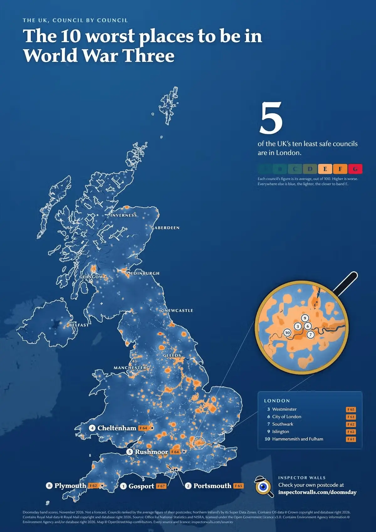
He told the Daily Star: "It's a thought experiment, but it's built on public maps and public data, and it faces a dozen other factors. So when you enter your postcode, it analyses it.
"It looks for the strategic targets nearby, like Ministry of Defence, any targets that we learned in war that had become strategic targets to hit enemies. It also calculates the hills between you and the targets.
"It calculates the wind, the rain, the geographical position of this place. Like, how is the weather? How is the winter? It also looks through the EPC (Energy Performance Certificate) data of this particular home".
While we've been reassured that the UK wouldn't get involved in a war, the government has warned us to stock up on essential items, that may be more down to the extreme weather that is expected from Super El Nino this winter.
Interestingly, the map does miss off areas such as Barrow-in-Furness, which is home to BAE systems, which has long been suggested as a potential target in any conflict.
You can see the top 10 list below:
- Gosport (F, 67)
- Portsmouth (F, 65)
- Westminster (F, 65)
- Cheltenham (F, 64)
- Rushmoor, Aldershot and Farnborough (F, 64)
- City of London (F, 63)
- Southwark (F, 62)
- Plymouth (F, 62)
- Islington (F, 62)
- Hammersmith and Fulham (F, 61)
Topics: Donald Trump, UK News, Vladimir Putin
 James Moorhouse