How 'Super El Niño' that will have catastrophic global consequences will impact UK

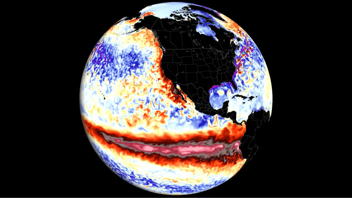
Global temperatures are expected to increase to record levels in the next five years with a 'Super El Niño' predicted for the end of 2026.
El Niño is a naturally occurring climate pattern which consists of unusually warm ocean surface temperatures in the central and eastern tropical Pacific.
It happens when normal, east-to-west trade winds weaken or reverse, causing warm water to pool along the Americas and disrupt global weather, often causing heavy rains in some regions and severe droughts in others.
The cycle switches between warmer El Niño periods and cooler La Niña periods every few years.
Advert
Following May's record-breaking temperatures in the UK, you might be wondering if the El Niño will affect us across the pond.
What is a Super El Niño?
"A 'super' El Niño is not an official scientific category, but it is a term sometimes used in the media to describe a particularly strong El Niño event," Met Office spokesperson Nicky Maxey told LADbible.
"There are increasing signals that El Niño is developing in the tropical Pacific. The tropical Pacific El Niño region is predicted to warm faster this year than any time so far this century, with sea‑surface temperature anomalies exceeding 2C in the central and eastern tropical Pacific, which would be notable by historical standards.
"While there is the potential for it to become a stronger event, it is still too early to determine exactly how strong it will be or what the precise impacts might be."
Experts say super El Niño events can trigger:
- Extreme global heat
- Flooding in some regions
- Droughts and wildfires in others
- Crop failures and food shortages
- Coral bleaching and damage to fisheries
How will the Super El Niño affect the UK?
Maxey says the potentially extreme climate pattern will 'indirectly' affect Britain and will be 'just one of several climate drivers influencing weather patterns in Europe and the UK'.
"Its impacts here in the UK are typically indirect, but it can increase the likelihood of more unsettled conditions later in the year, including a higher chance of wetter weather during autumn and early winter," Maxey adds.
"However, any potential impacts will be assessed in more detail later in the year as forecasts evolve."
How to prepare for a Super El Niño
Meteorlogy Professor Emily Black, a professor of terrestrial processes and climate, research division lead for Earth Observation and Space told LADbible that 'the impacts of El Niño are generally not strong enough to require a specific response'.
"However, as in any winter, it is sensible to remain prepared for storms, flooding and occasional cold snaps," Professor Black added.
"In tropical regions, preparedness depends much more directly on the expected regional impacts of El Niño. For example, where El Niño is associated with drought, farmers may consider using more drought-tolerant or faster-maturing crop varieties, and may need to delay planting slightly if the rains are slow to become established."
How does an El Niño year happen?
Strap in, folks. It’s time for some science.
It all starts with something called trade winds, which are permanent winds around the equator which usually blow from east to west. So in the equatorial Pacific, they blow from the Americas towards Australia and New Zealand.
As the wind blows the water east, it is warmed by the sun, so by the time it gets to the other side of the Pacific, the warm water causes hot air to rise, leading to warm, wet and unsettled weather. Meanwhile, colder water from deeper in the ocean rises in the east to replace the water blown west.
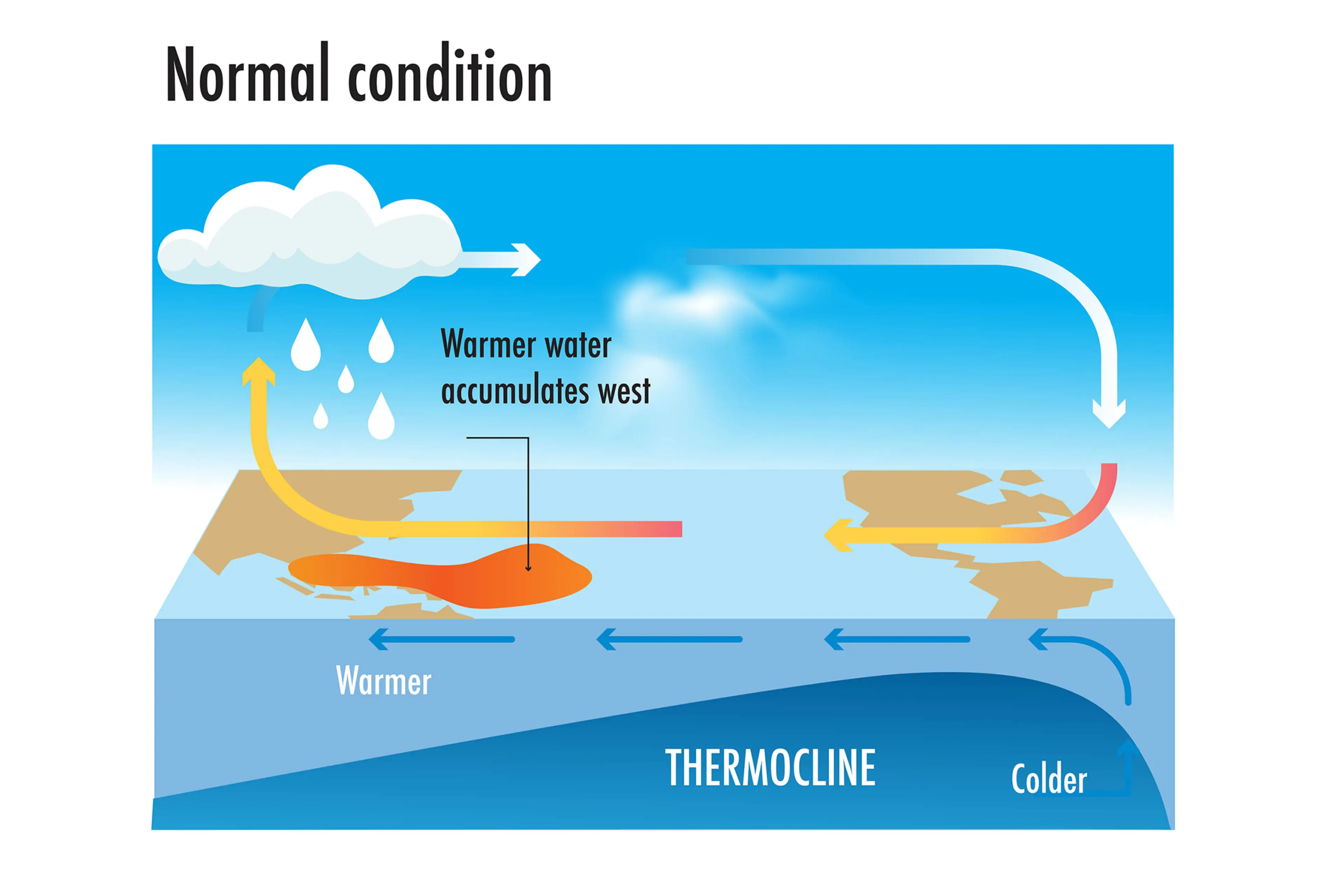
But during El Niño years, this gets disrupted.
When trade winds are weakened or even reversed, the temperature difference between the east and west is cancelled out, and usually cold parts of the ocean warm up.
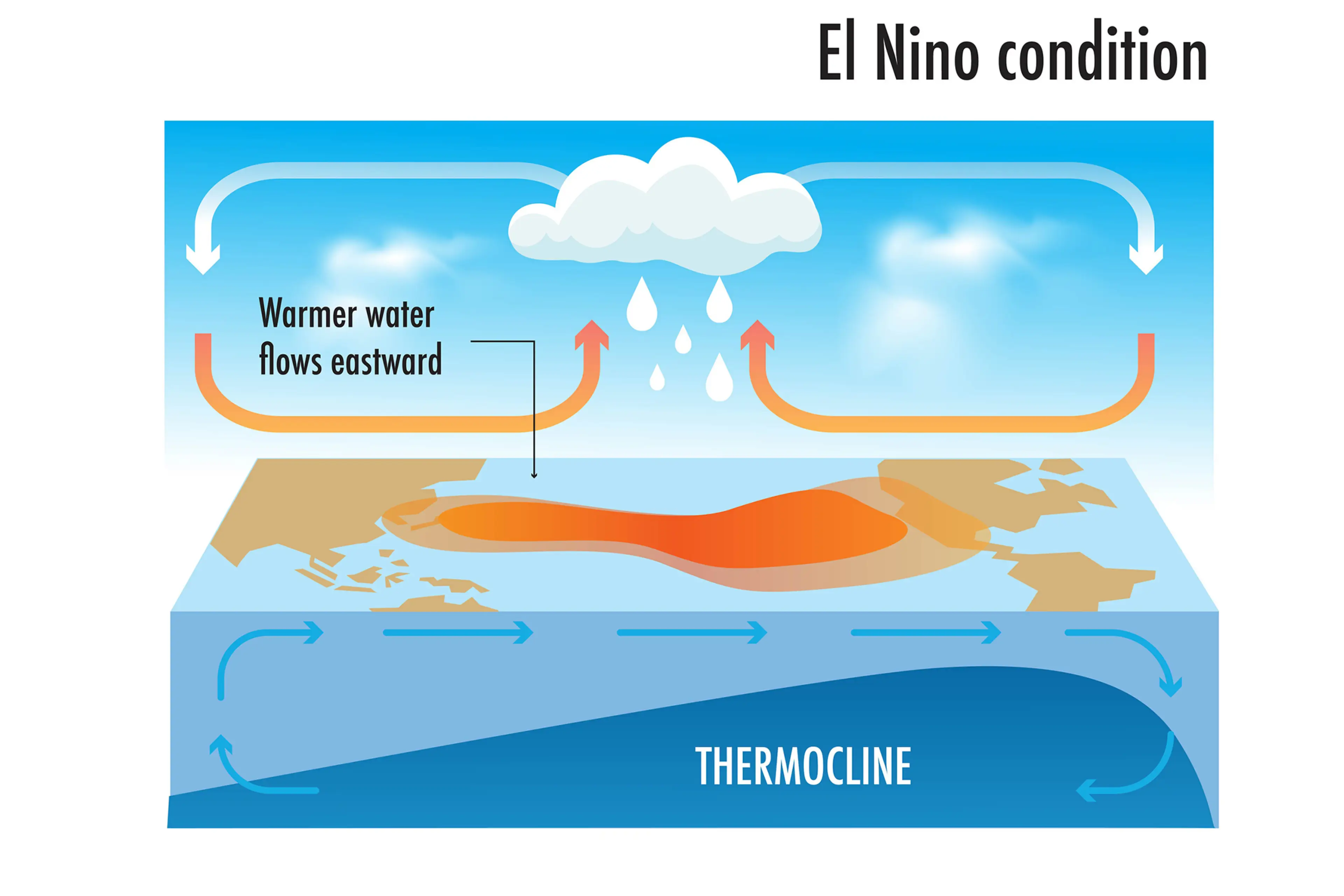
Rainfall and wind patterns change across the equatorial Pacific, which has a knock-on effect around the world.
Anyone else's head hurt a bit?
 Anish Vij