NASA shares new image of ‘Super El Niño’ that could have potentially devastating impact
NASA has shared new data which confirms that an El Niño is on the way.
Earlier this month, the US National Oceanic and Atmospheric Administration (NOAA) confirmed that El Niño conditions had developed in the Pacific Ocean, after recording an increase in sea temperatures.
The confirmation follows weeks of reports that the 2026 El Niño would be a 'super' one, with ocean temperatures increasing as much as 2°C above average.
While the exact impact of the El Niño won't become apparent until later in the year, NASA has recently released further evidence to prove that the weather phenomenon is well and truly on its way, an increase in sea surface height.
Advert
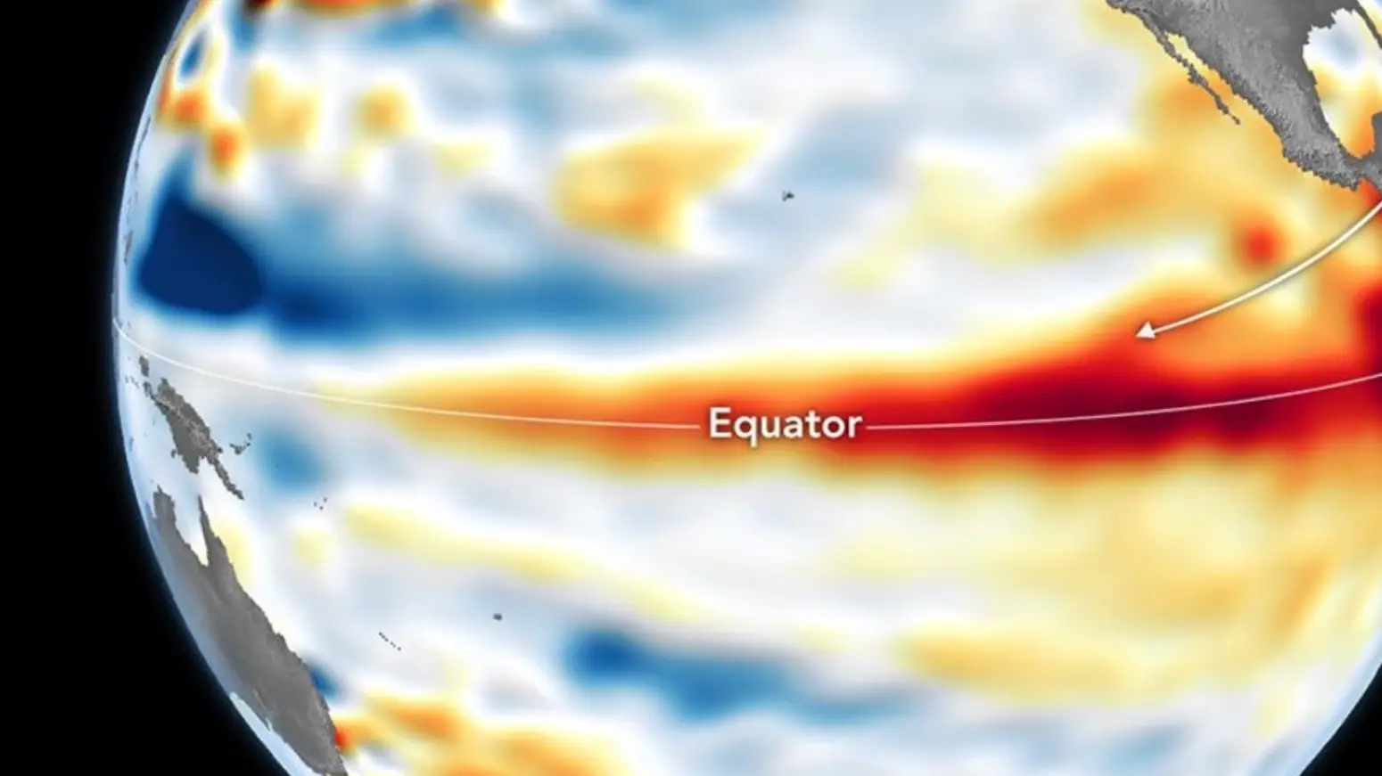
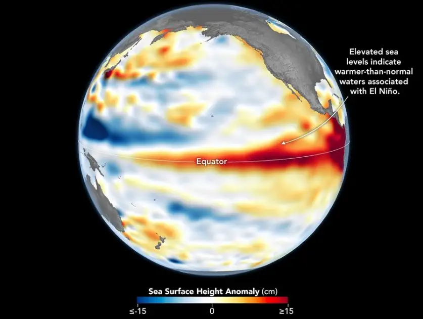
Releasing satellite data obtained earlier this month, the space agency revealed data evidencing an increase in sea height around the equatorial Pacific Ocean.
What does sea level have to do with El Niño?
Water expands when the temperature rises, which means that a warmer ocean will almost lead to an elevation in sea height.
In the data released by NASA, anomalies in sea surface height are recorded around the central and eastern Pacific Ocean, correlating with the warmer temperatures recorded.
Take a look at the graph below to see the elevation in sea surface height:
What happens during a 'super' El Niño?
It's worth noting that a 'super' El Niño is not a scientific term exactly, but a popular way of describing a particularly strong El Niño event.
However, meteorologists have long been suggesting that this year's El Niño is likely to be a strong one.
"Met Office predictions have been signalling for some time that this latest El Niño is likely to be a significant event – perhaps one of the most intense on record - with the potential to bring severe impacts to a number of regions of the world as the event unfolds," Professor Adam Scaife, Head of Long-Range Forecasting at the Met Office, recently said.
"It is also highly likely that the El Niño will cause a temporary spike in global annual temperature with the residual heat potentially making next year the hottest in the global series from 1850."
And it's likely to have an impact all over the globe.
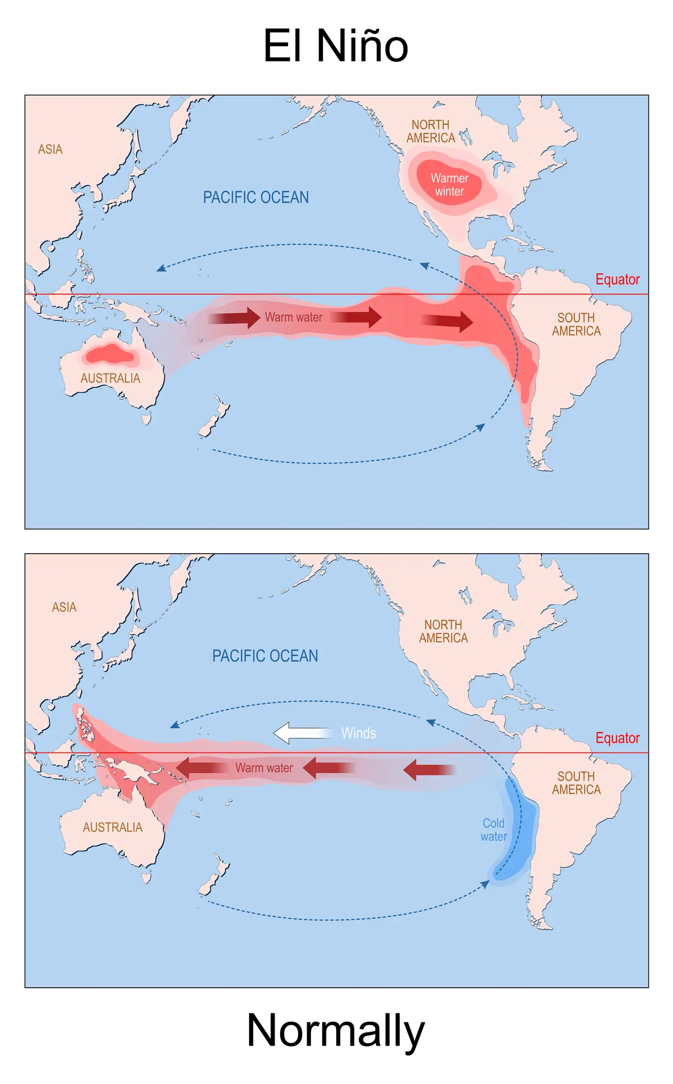
This is because El Niño events impact atmospheric circulation, leading to heavy rainfall in some places and droughts in others.
How will this impact the UK?
According to the National Centre for Atmospheric Science, an El Niño can impact the UK in two ways: a wetter winter and disruption to global supply changes.
While we're likely to enjoy a warm end to the summer, previous El Niños have coincided with nationwide storms and flooding as the UK heads into its colder months, with 2023's Storm Babet coinciding with an El Niño.
Meanwhile, a particularly strong El Niño in 2015 coincided with flooding across the UK and Ireland.
When it comes to impacts on global supply chains, this likely means an increase in our bills, with the World Bank warning last week that El Niño could lead to an inflation in global food prices.